


![]() Wells Project
Wells Project
![]() License Articles
License Articles
![]() Wells HCP
Wells HCP
![]() Annual Compliance Reports
Annual Compliance Reports
|
|
|
|
|
|
|
|||
 |
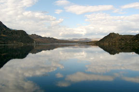
Wells Reservoir
The Wells Reservoir is approximately 30 miles long. The Methow and Okanogan rivers are tributaries of the Columbia River within the Wells Reservoir. The Wells Project boundary extends 1.5 miles up the Methow River and 15.5 miles up the Okanogan River. The normal maximum surface area of the reservoir is 9,740 acres with a gross storage capacity of 331,200 acre-feet and usable storage of 97,985 acre-feet at elevation 781. Most of the reservoir shoreline is steep with slopes rising 20 to 40 feet above the reservoir. Exceptions include the shoreline in Pateros, in Brewster, at the mouth of Okanogan River, Washburn Island, and the Bridgeport Bar. These shorelines vary between 3 and 10 feet above the reservoir.
|
|
Send questions or comments about the Douglas County PUD Relicensing website to
relicensing@dcpud.org Copyright © 2013 Douglas County PUD. All rights reserved.
|
 The reservoir forms the
boundary between Douglas County on the south and east and Okanogan and
Chelan counties on the north and west. The reservoir also forms a portion of
the western boundary of the Colville Indian Reservation, which lies east of
the Okanogan River and north of the Columbia River. This region is sparsely
populated. The cities of Pateros (643), Brewster (2,189) and Bridgeport
(2,059) are municipalities located along the Wells Reservoir (US Census
2000). The reservoir shoreline is generally owned in fee title by Douglas
PUD. Most of the lands upland of the Project boundary are privately owned
with tracts of federal and state owned land interspersed. Most of the land
surrounding the project is used for agricultural purposes.
The reservoir forms the
boundary between Douglas County on the south and east and Okanogan and
Chelan counties on the north and west. The reservoir also forms a portion of
the western boundary of the Colville Indian Reservation, which lies east of
the Okanogan River and north of the Columbia River. This region is sparsely
populated. The cities of Pateros (643), Brewster (2,189) and Bridgeport
(2,059) are municipalities located along the Wells Reservoir (US Census
2000). The reservoir shoreline is generally owned in fee title by Douglas
PUD. Most of the lands upland of the Project boundary are privately owned
with tracts of federal and state owned land interspersed. Most of the land
surrounding the project is used for agricultural purposes.